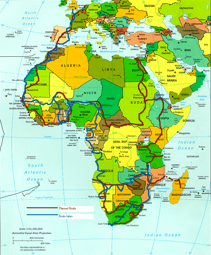
More words will be added to the diary sections of each country, once we've been to them and to a cyber cafe to update the web site. This is the route we plan to take.
The Planned Route
Click on each country to read the diary.
A Blue line will be drawn as we go along because this trip is about feeling free to deviate as the mood takes us -
visa requirements notwithstanding! Already we have made a couple of changes to the proposed route, chief among these being avoiding the Dafur region of the
Sudan where there is alleged ethnic cleansing going on. Instead, we will go from N'Djamena in Chad, through the
Central African Republic, entering Sudan from the South. Other changes have been made to the route followed from Sudan
to Egypt and again from Egypt back down south through the Sudan and into Ethiopia - which has come about from using
a better map! So, click on that part of the map that interests you, to see what happened there - but only if the blue line has
got that far! And if the little scrolling banners irritate you, just double-click on them to see a disappearing trick ...
The timing is based on August 2004 being a good time to leave jobs, etc., as well as rent out the flat in Edinburgh.
It is also based on probable climate conditions on the way. Although this route should take around nine months, we will allow a full year for the trip.
Comprehensive research into the climate in Southern Africa has not been done because we don't know when
we'll be there, and there will be some zig-zagging anyway. Navigation will be done using three Michelin maps: 741 of north and west Africa, 745 of north and east Africa
and 746 of central and southern Africa and Madagascar, as well as the National Geographic
Africa Adventure Atlas and, of course, a GPS.
Because I was a novice at using a GPS, it was recommended
that I begin with the Garmin GPS 72, which is not map capable. Although I had thought that the budget was exhausted,
and hence we would not be upgrading now that I am no longer a novice, I now have reason to dispute this wisdom.
It would be a distinct navigational advantage to have a map capeable GPS, in the event that the laptop dies or is stolen.
In this set-up, of what has become our back-up GPS, the GPS connects to the laptop with the
same set of leads that powers it from a cigarette lighter, while the laptop is powered via an inverter
from the second battery. The laptop has been loaded with Garmin WorldMap software, which is able to plot
one's position on the map and track movements on screen in real time.
In this setup, the GPS is more stand-alone. This is the garmin GPSMap76S, which is preloaded with a world map.
It was thoroughly tested during our sojourn to Ireland to test systems more mechanical (also on what passes for a dash board,
is an external / internal thermometer and clock). What the GPS stores, can be
downloaded to the Garmin WorldMap format. The idea is to record and save geographical data for
each leg of the trip so that others can use that data as we have used records posted by folk who have done
this sort of trip before. Well, it would be rude not to ...!